Photo Gallery » Tourist attractions in Iceland
Iceland is a country of stunning natural beauty, with a diverse landscape that includes glaciers, volcanoes, lava fields, geysers, hot springs, waterfalls, and black sand beaches. A trip to Iceland can be an unforgettable experience for anyone who loves the outdoors and the beauty of nature.


Iceland is a country of stunning natural beauty, located at the meeting point of the European and North American tectonic plates. This location is what makes the country so geologically active. In Iceland, you can see volcanoes, geysers, hot springs, glaciers, ice caves, black beaches, stunning mountains, glacial rivers, thousands of impressive waterfalls and many other natural attractions.
Picture number (ID): 3034 Google Map
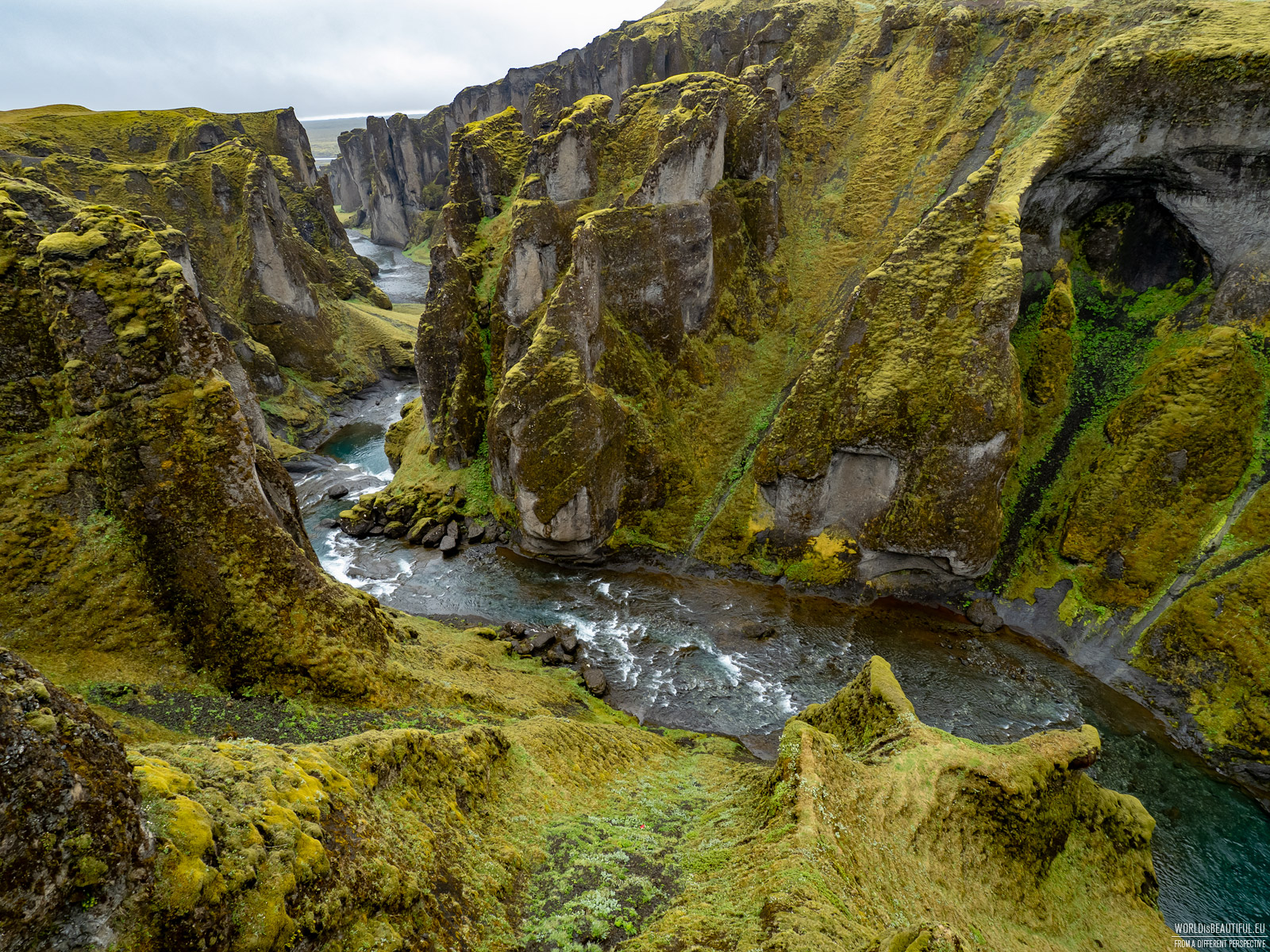
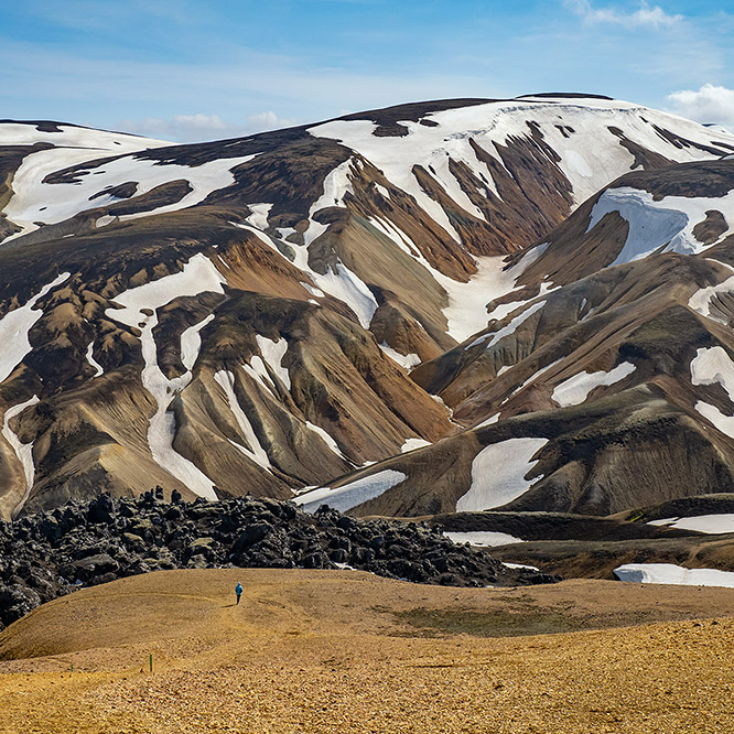
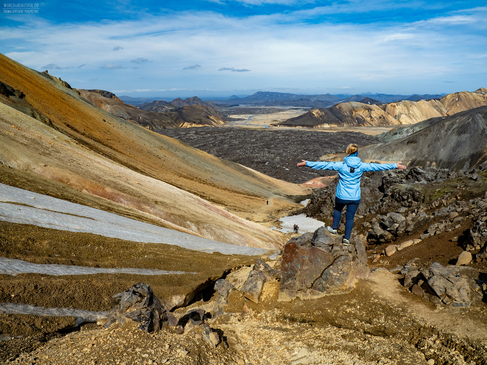
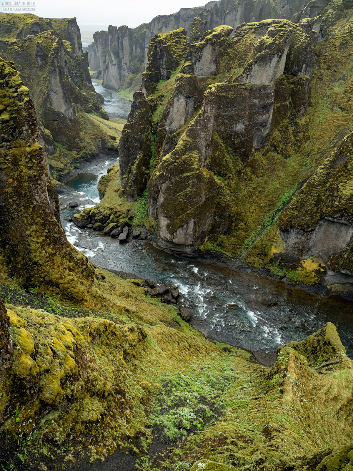
Iceland is a country of stunning natural beauty, best explored by car. This allows you to plan your own route and stop at places that interest you the most. Renting a car in Iceland is easy, though not cheap. There are many rental companies near the airport. It is worth choosing a car with slightly higher suspension, which will cope with uneven terrain. There are many car routes in Iceland to choose from, depending on the time you have for sightseeing and your interests. A popular route is Road 1 along the south coast, which leads through places such as: Seljalandsfoss and Skógafoss waterfalls, beaches in Vík, Vatnajökull glacier, Hekla, Katla and Eyjafjallajökull volcanoes, Landmannalaugar rainbow mountains and numerous canyons for example Fjaðrárgljúfur (in the photo). On the way back to Reykjavík, you can see the impressive Strokkur geyser and the rift between two continental plates in Þingvellir National Park. Thanks to mobility, you can also easily reach smaller, hidden treasures of Iceland, which appear on the map with surprising frequency. A road trip around Iceland is a truly unforgettable experience. With so much natural beauty to see, you're sure to have a once-in-a-lifetime adventure.
Picture number (ID): 3033 Google Map
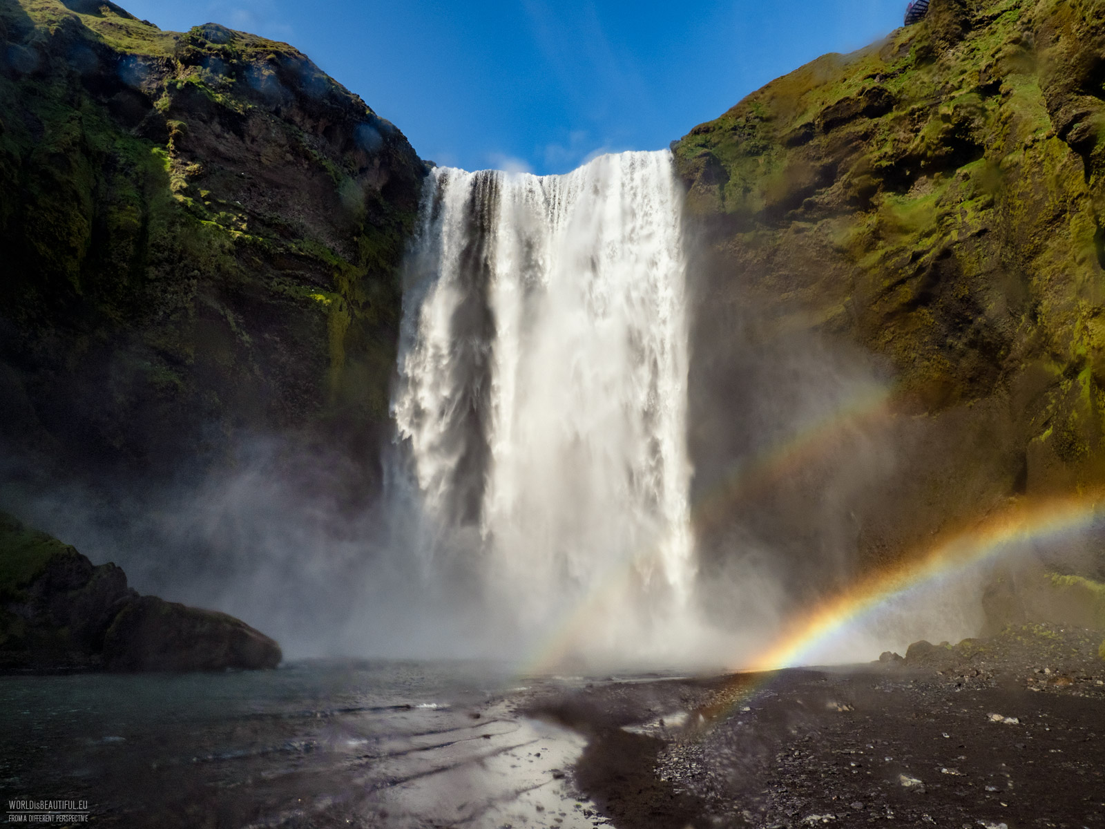
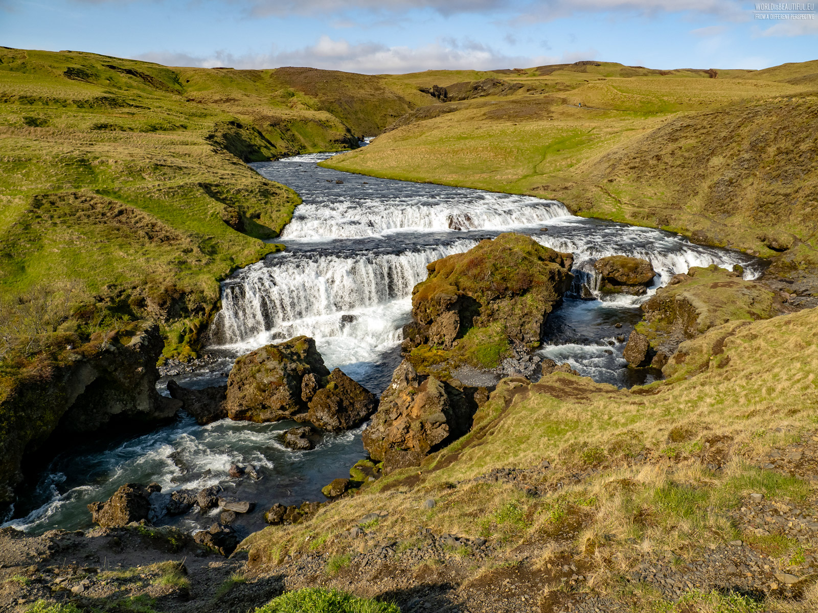
Iceland is a country of waterfalls. There are over 10,000 waterfalls on the island, from small and charming to powerful and majestic. Waterfalls can be found everywhere, from the coast to the interior of the country. Some of the most famous and popular waterfalls are located on the Golden Circle, a popular tourist route in southern Iceland. One of the most recognizable waterfalls in Iceland is Skógafoss. Skógafoss is a massive waterfall with a height of 60 meters and a width of up to 25 meters. A large amount of water cascades down the canyon, creating a spectacular sight. Another popular waterfall is 60-meter Seljalandsfoss. There is a path that leads behind the waterfall and you can go there, but you need to wear waterproof clothing because everything is wet after a few seconds. Gullfoss is a cascading waterfall with a height of 32 meters. The water cascades down the canyon, creating an amazing sight. We also drove inland to see 128-meter-high Háifoss - it is one of the highest waterfalls in Iceland - and I have to say its size is impressive! Waterfalls in Iceland are not only beautiful sights, but also a source of energy. The water from waterfalls is used to generate electricity.
Picture number (ID): 3020 Google Map
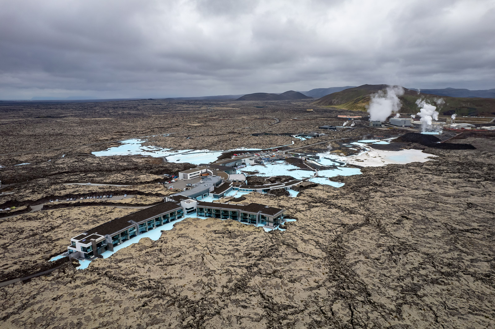
Blue Lagoon, located in the heart of Iceland's scenery, is a geothermal pool and spa that transports guests to a magical world of blue waters and surrounding volcanic rocks. The mineral-rich water, fed by hot springs, is not only relaxing but also beneficial to health. A visit to the Blue Lagoon is a unique experience for body and soul, where you can immerse yourself in warm geothermal waters, enveloped in a mysterious mist. This popular place is a harmonious combination of the harshness of the Icelandic landscape with the extraordinary use of natural resources. In the distance in the photo you can see a geothermal power plant.
Picture number (ID): 3036 Google Map
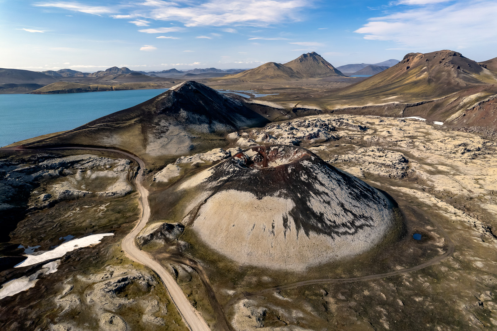
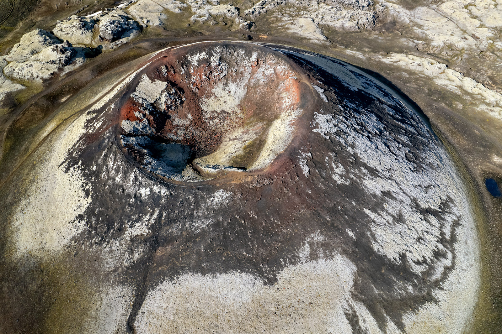
Iceland is a country located on the Mid-Atlantic Ridge, where two tectonic plates meet. This makes Iceland one of the most volcanically active places on Earth. Hekla, at 1,488 meters high, with its evocative name of "Gate to Hell," commands respect for its appearance and activity. Eyjafjallajökull, known for its global eruption, is a reminder of the dynamic forces that lie deep within the Earth. Traveling through Iceland, one can experience both the majestic beauty of these volcanoes and the awe of their powerful impact on shaping the landscape of this extraordinary island. Volcanic eruptions create new land, and volcanic ash enriches the soil. Volcanoes are also a source of geothermal energy, which is used to heat homes and generate electricity.
Picture number (ID): 3019 Google Map
How many volcanoes are in Iceland
There are about 200 volcanoes registered in Iceland, of which about 30 are considered active. In recent years, there have been several volcanic eruptions in Iceland. The most significant was the eruption of the Fagradalsfjall volcano on the Reykjanes peninsula, which began on March 19, 2021. The eruption lasted for 8 months and was the first volcanic eruption in the region in 800 years. In July 2023, an eruption began on the mountain Litli-Hrutur, near the Fagradalsfjall volcano on the Reykjanes peninsula. The latest volcanic eruption began in the early hours of January 14, 2024, in the vicinity of the Hagafell mountain near the town of Grindavík. One of the most significant and well-known volcanic eruptions in Iceland was the eruption of the Eyjafjallajökull volcano in 2010. It began on March 20, 2010, and lasted for a month. The eruption caused the emission of a large amount of volcanic ash, which spread over a significant area of Europe, causing the closure of airspace and the cancellation of thousands of flights, as well as disruptions to air traffic around the world.
Picture number (ID): 3032 Google Map
Driving in Iceland is a great way to see the country and have the most freedom. The road quality is generally good, but it can vary depending on the region and time of year. Most major roads are well-maintained asphalt, but local roads can be narrow and unpaved. It is a good idea to rent a car with high ground clearance and larger wheels. When picking up your car, pay attention to the condition of the tires. If you are planning on driving on side roads, always pay attention to the signs. It is often the case that the asphalt suddenly ends and you can drive onto a gravel road with large potholes or rocks. When planning your trip, pay attention to whether the navigation has not plotted a route that leads through a river. Never drive into a river with a rented car, even if it seems very shallow. I have heard from people who live in Iceland that in season they pull tourists out of rivers or streams every day, and such an attraction is very expensive. Additionally, pay attention to the travel time. If the navigation shows that you will be driving 30 kilometers for an hour and 20 minutes, know that it will not be an easy ride.
Picture number (ID): 3031 Google Map
Iceland offers a variety of attractions throughout the year, making the choice of the right time to travel depend on your preferences. Summer, from June to August, is the warmest time, with long days, green landscapes, and seabird activity. It is a great time to see volcanoes, geysers, black sand beaches, canyons, or go hiking in the mountains. Winter, from October to March, the ice cover becomes harder, making it an excellent time to visit ice caves and go glacier hiking. To see the aurora borealis, it is best to go between September and March, but it is important to note that the darkest nights are from November to January and these are the best conditions for observing this amazing phenomenon. Ultimately, each season has something unique to offer on this fascinating island.
Picture number (ID): 3030 Google Map

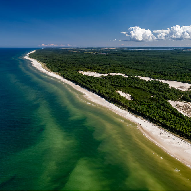
Vík í Mýrdal is a small village located in southern Iceland, on the coast of the Atlantic Ocean. It is the southernmost point in the country. Vik is known for its black sand beach, Reynisfjara, which is considered one of the most beautiful beaches in the world. This beach is surrounded by high cliffs. In the ocean by the beach are the Reynisdrangar rock formations - characteristic rock pillars, which according to legend are petrified trolls. Vik is also a good place for bird watching. From May to August, thousands of puffins nest on nearby rocks. On a hill above the village stands one of the most photographed churches in Iceland. I marked on the map the bar Súpufélagið, where you can eat very good hearty soups.
Picture number (ID): 3021 Google Map
How to dress to explore the island
Planning a trip to Iceland, the right clothing is essential to adapt to the changing climate. I recommend layered clothing, starting with thermal underwear, through an insulation layer, and ending with a protective outer layer. A functional rain jacket and pants are essential for protection from rain and wind. Hiking boots are essential for comfortable movement on a variety of terrain. A head covering, gloves, and sunglasses are essential accessories. We visited the island in June and temperatures rarely exceeded 10 degrees Celsius (50 degrees Fahrenheit). Although there was a day when it suddenly got very warm and we descended from the mountains in T-shirts. Additionally, while traveling around the island, you can find hot springs in many places - therefore it is always worth having a swimsuit and a towel with you.
Picture number (ID): 3029 Google Map
How to Travel to Iceland on a Budget
Iceland can be affordable, especially for a group of four. Renting a car with friends splits the costs of fuel and rental. Airbnb accommodations are an economical alternative, and cooking your own meals and shopping at larger stores (such as Bonus, Kronan) can help save on food. Switching to a vegetarian diet will also significantly reduce costs (fish and meat are really expensive here). Don't plan on buying alcohol - if you want to enjoy a glass of wine or a drink, bring it with you. Most attractions in Iceland are free. You only have to pay for parking. Sometimes, you can find free parking even near popular attractions - before you park, take a close look at the Google map because many of these places are marked. If you can, travel off-season. Prices are much lower then, but be aware: some hiking trails aren't opened until mid-June. Explore Iceland on your own. Group tours are expensive.
Picture number (ID): 3028 Google Map
When is the warmest time to visit Iceland
If you're planning to visit Iceland during the warmest period, head there in the summer, especially between June and August. During this time, temperatures rise to an average of 10-15 degrees Celsius, making conditions milder. The long days offer more sunlight for exploring picturesque places. In June, it stays bright until midnight, and then it becomes gray. Summer also brings green landscapes, blooming meadows, and abundant seabird activity. It's the perfect time to experience the beauty of Iceland in warmer weather.
Picture number (ID): 3027 Google Map
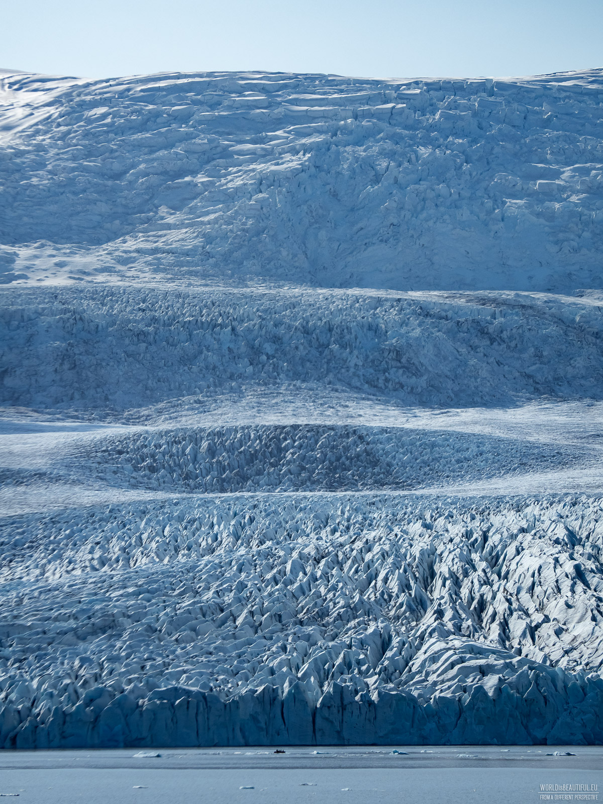
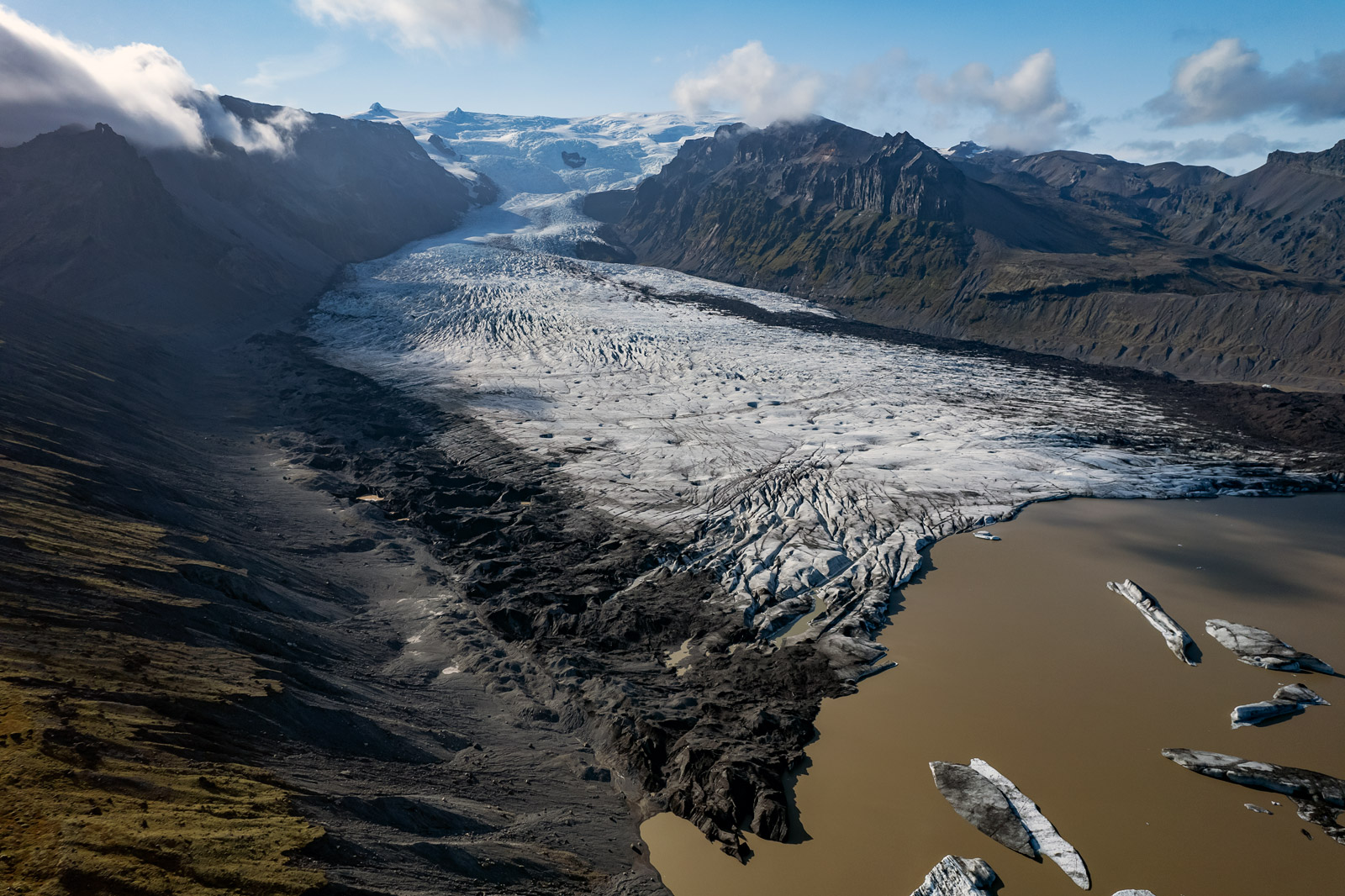
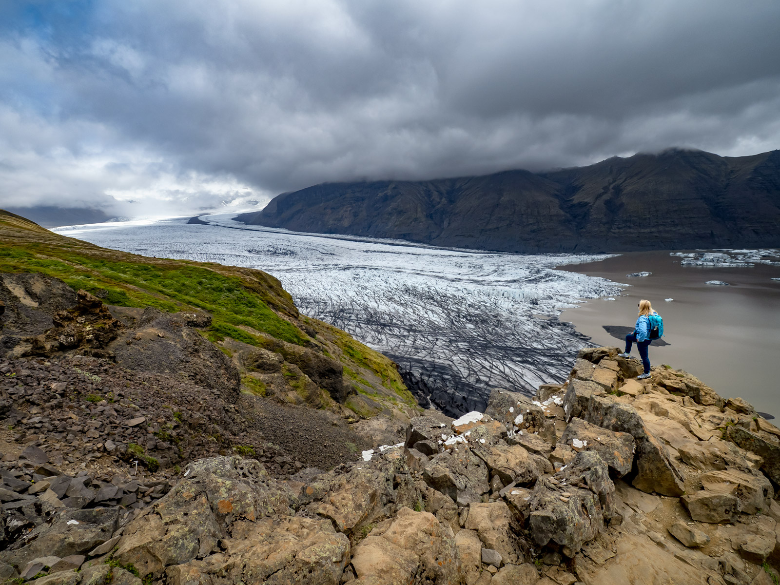
Iceland is a land of ice and fire. The island is home to about 130 glaciers, which cover about 10% of its surface. Iceland's glaciers are one of its most valuable natural assets. The Vatnajökull glacier (pictured), the largest in Europe, hides volcanic secrets and picturesque ice caves beneath its surface. Icelandic glaciers are symbols of the power of nature, which are still evolving, highlighting the dynamic nature of this island nation. Iceland's glaciers are affected by climate change. In recent years, it has been observed that these glaciers are melting at an alarming rate. It is estimated that in the last 20 years, the surface area of Iceland's glaciers has decreased by about 10%.
Picture number (ID): 3025 Google Map
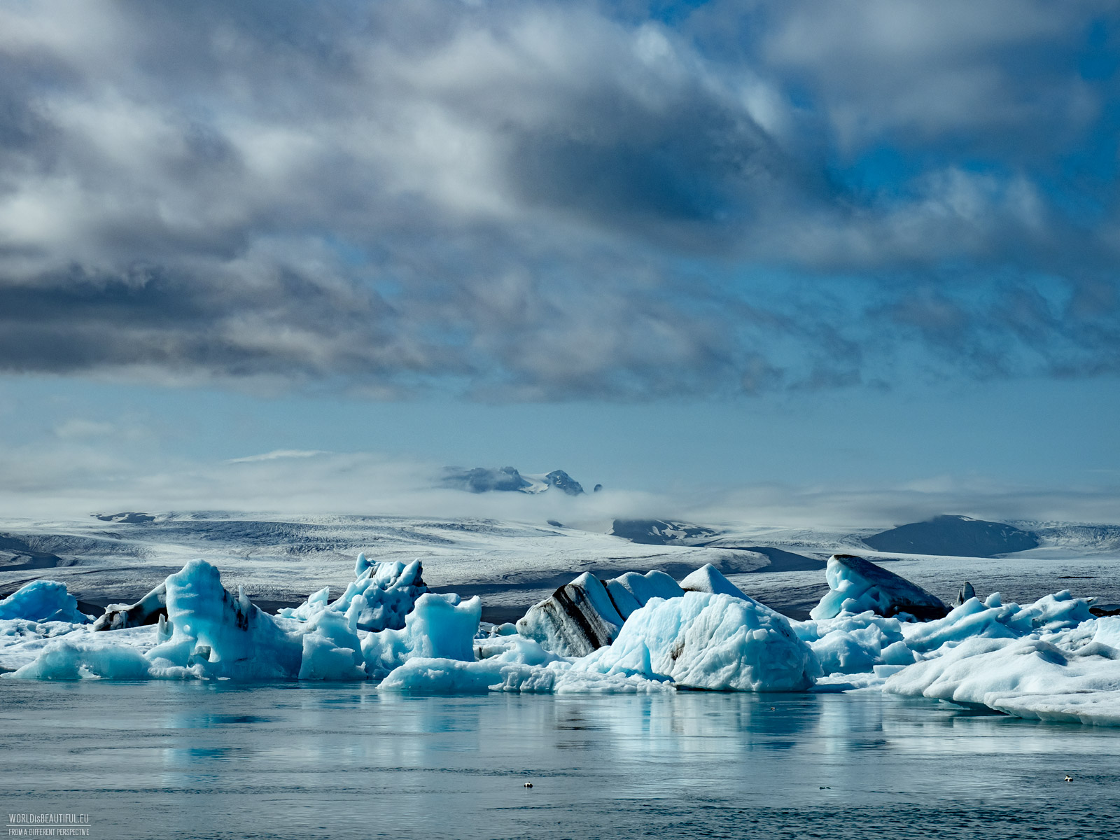
Jokulsarlon is a glacial lagoon located on the south coast of Iceland. It is one of the most popular tourist destinations on the island, thanks to its breathtaking views. The lagoon is home to enormous icebergs that calve off the glacier and drift across its surface. The icebergs then flow out to the ocean and are eventually washed up on the beach. Jokulsarlon is also home to a variety of wildlife, including seals and birds. An amphibious boat tours are a great option for those who want to see the icebergs up close and learn more about the history and geology of the lagoon. During the tour, which lasts about an hour, a guide tells you about how the lagoon was formed, how it changes over time, and what animals you can find there. A kayak tour is a more active way to explore the lagoon. Kayaks allow you to get closer to the icebergs and reach places that you cannot reach by boat. The tour usually lasts about two hours and gives you the opportunity to admire the icebergs up close, as well as observe seals, which often stay near the lagoon. Both types of tours are a great opportunity to see this amazing place from a completely different perspective.
Picture number (ID): 3026 Google Map
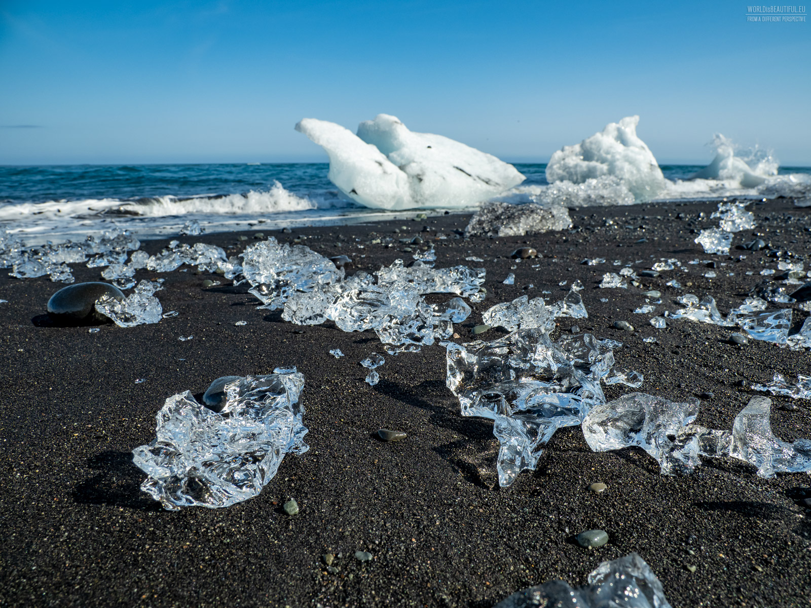
Diamond Beach is one of the most popular tourist attractions in Iceland. It is located on the south coast of the island, near the Vatnajökull glacier. The beach is named after the ice shards that lie on it, which come from melting icebergs. The ice on Diamond Beach is varied in shape and size. You can find small and large shards, as well as entire icebergs. The color of the ice also varies, from white and blue to gray and black. The best time to visit Diamond Beach is in spring or fall, when the ice is still visible but not yet completely melted. In the summer, the ice is often hidden underwater, and in the winter it may be covered in snow.
Picture number (ID): 3035 Google Map
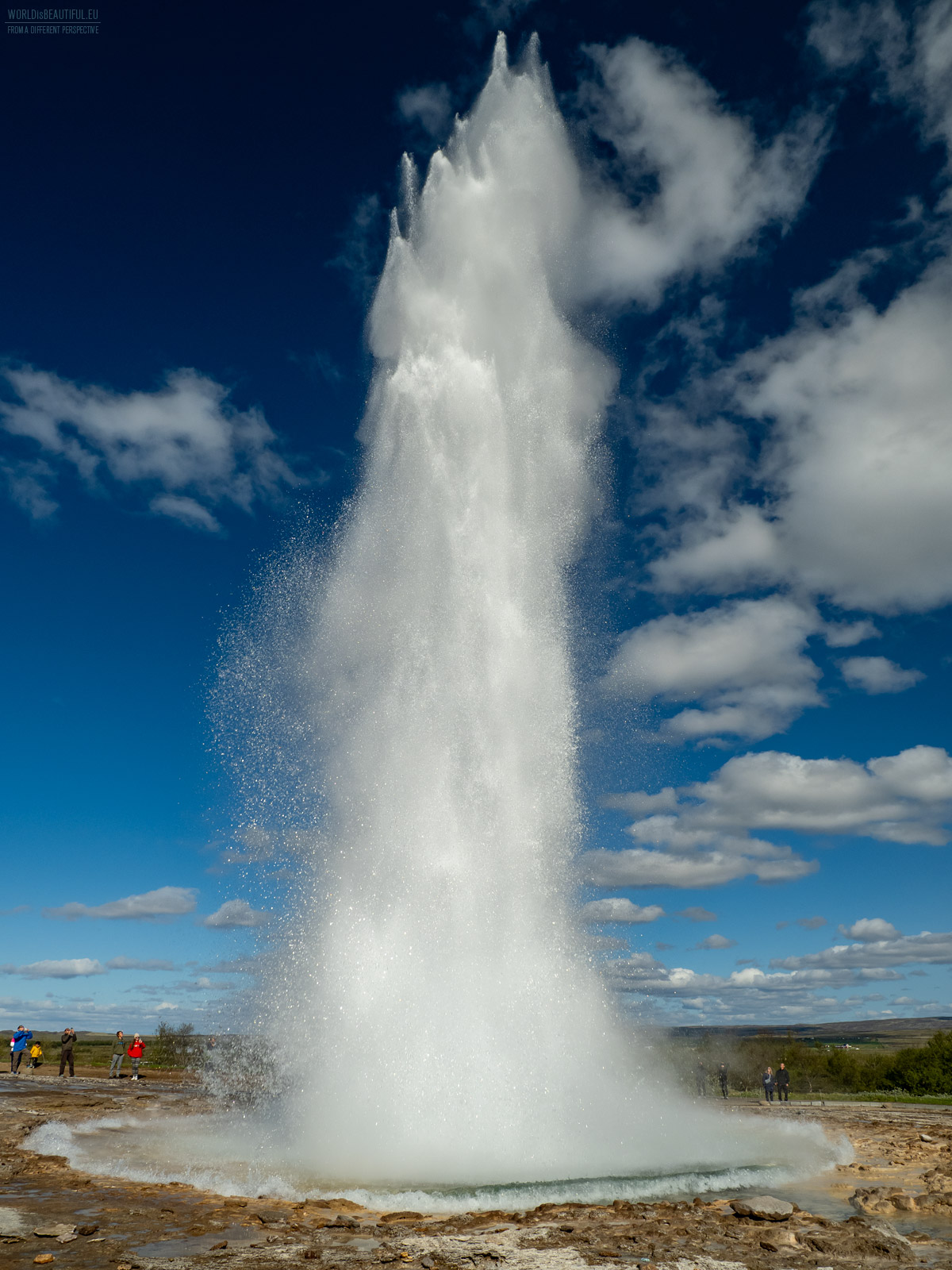
The largest geysers - Strokkur
Iceland is a land of geysers. There are over 250 geysers in Iceland, of which about 30 are active. Geysers are hot springs that erupt, shooting a column of water and steam up to several tens of meters high. Geysers are formed as a result of geothermal activity. The water that feeds the geyser is heated by hot rocks beneath the ground. When the water temperature reaches the right level, an eruption occurs. Geysers are one of the most popular natural wonders of Iceland. They attract tourists from all over the world who want to see this amazing phenomenon. The geyser in the photo is Strokkur, one of the most popular geysers in Iceland. It is located in the Haukadalur Valley, in the southwestern part of the island. Strokkur erupts every 5-10 minutes on average, shooting a column of water up to 30 meters high.
Picture number (ID): 3024 Google Map
The highest mountain in Iceland
Hvannadalshnúkur is a majestic mountain in southern Iceland, and the highest peak in the country. The peak is part of the Vatnajökull glacier, which is the largest glacier in Europe. Rising to an impressive 2,110 meters above sea level, Hvannadalshnúkur is often summited by avid climbers and adventure enthusiasts. Climbing Hvannadalshnúkur is a unique challenge that rewards its summiters with not only stunning panoramas, but also a sense of triumph over nature. The peak is challenging to climb, requiring good physical fitness and mountaineering skills. The first ascent of the peak took place in 1813. Hikes to Hvannadalshnúkur are organized by many tour companies in Iceland. Hikes are led by experienced guides who provide gear and essential information. The price of hikes to Hvannadalshnúkur ranges from around 300 to 500 euros per person. The price depends on the length of the hike, the number of participants, and the services offered.
Picture number (ID): 3023 Google Map
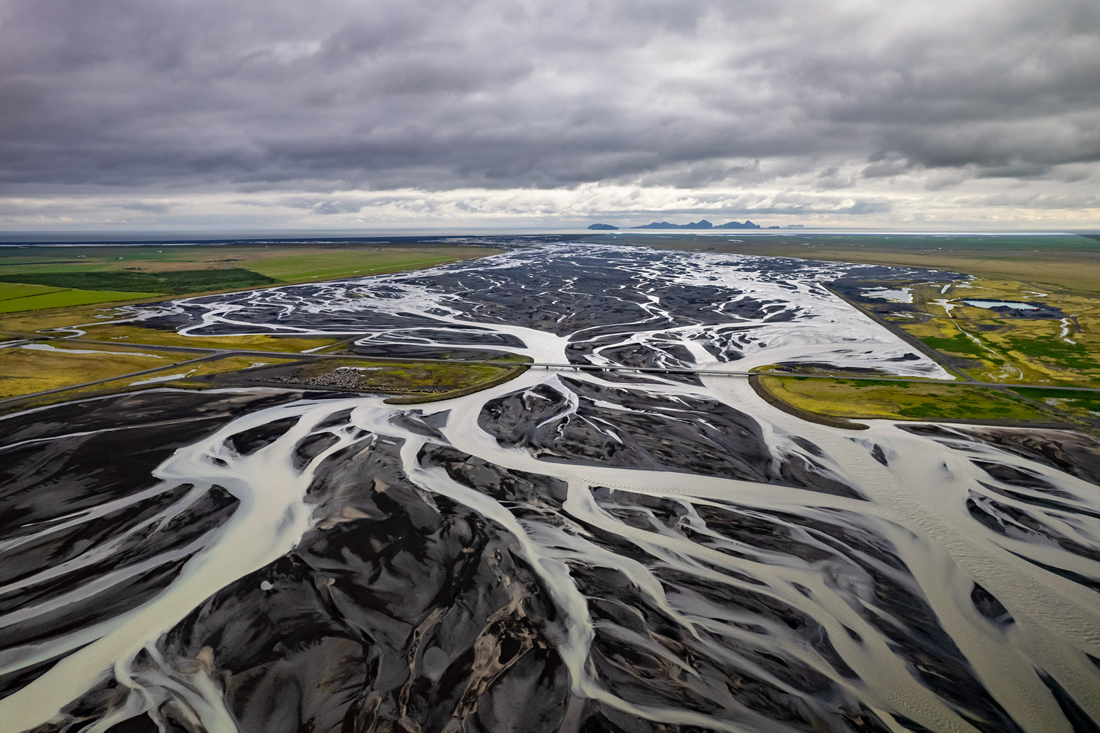
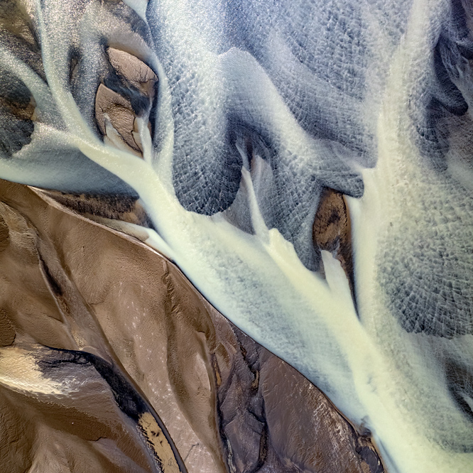
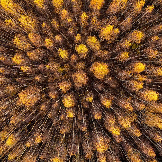
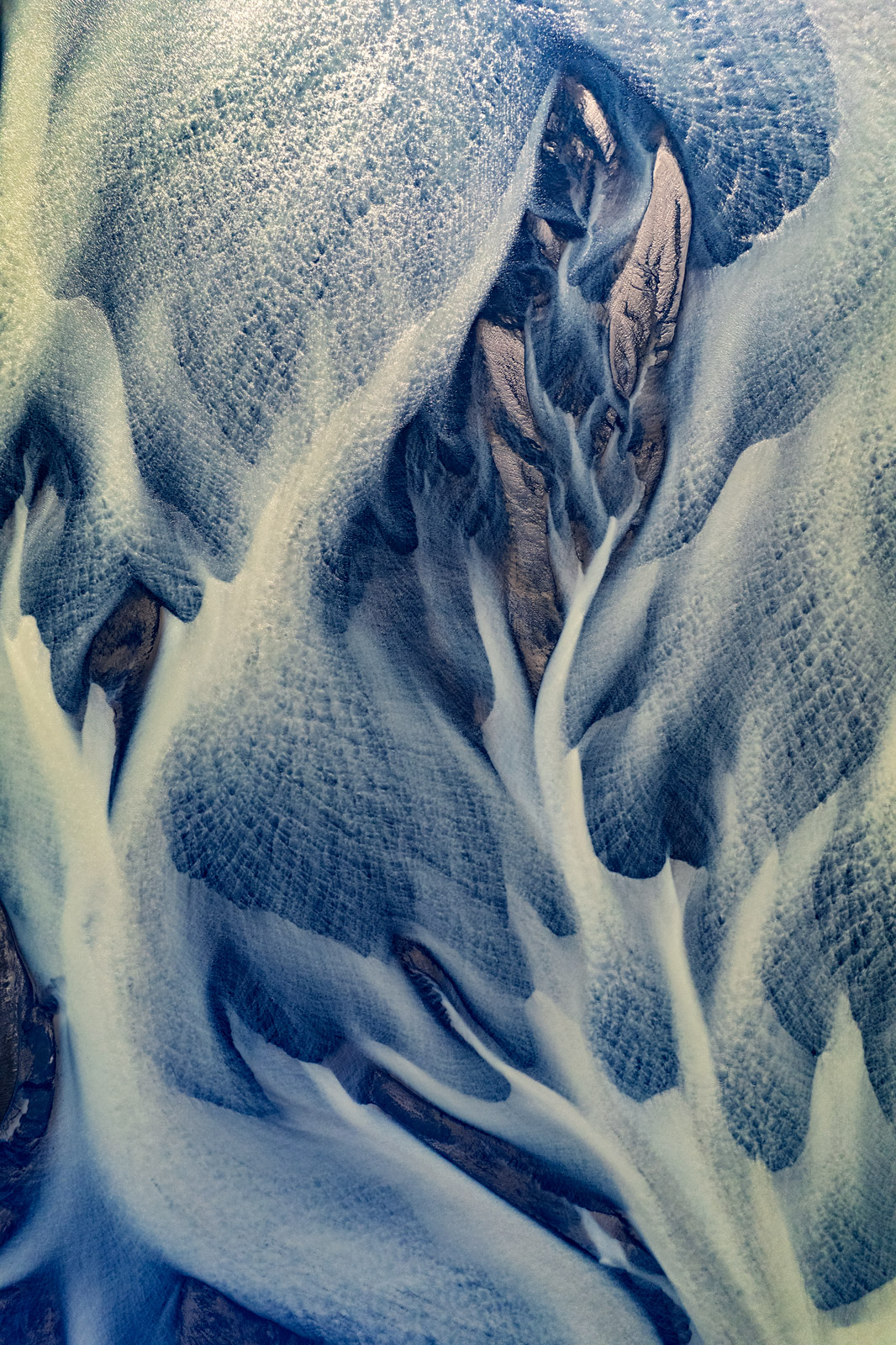
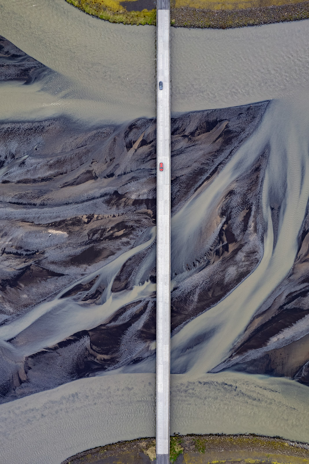
Glacier rivers are formed by the melting and flowing of water from the surface of a glacier. Glacier rivers can be very powerful and can carry large amounts of sediment. Glacier rivers are often very muddy because they contain suspended particles of ice and rock. The water in a glacier river can also be very cold, as it comes directly from the glacier. Glacier rivers can be dangerous places for people. They are often deep and strong, and the currents can be very powerful. From above, a glacier river looks like an impressive tangle of streams and rivers. You can see more photos of glacial rivers in the gallery: The Art of Nature
Picture number (ID): 3022 Google Map
A trip to Iceland is a fascinating experience, mainly for nature lovers. The country impresses with its contrast and endless variety of picturesque landscapes. Every few kilometers, the landscape changes drastically and surprises with its uniqueness. During the tour, you can admire gigantic waterfalls, huge glaciers, discover mysterious caves, bathe in hot springs, and even admire the Northern Lights. Iceland also offers unique opportunities to observe whales and seabirds. A visit to the capital, Reykjavik, allows you to learn about the local culture, with interesting museums and culinary experiences. It is a magical place where nature rules, and every corner hides something unusual, making a trip to Iceland an unforgettable adventure of a lifetime. You can see more photos from Iceland in the galleries: Rainbow Mountains in Iceland, The Art of Nature.
Picture number (ID): 3018 Google Map
Find an apartment
See other galleries: